Yonge Street - the mother of all Toronto Streets? With claims to being the longest street in Canada. (Thus this will be one of the longest blog entries I have done about walking across Toronto)
Yonge Street is
"...the name bestowed on the country’s longest street, which was partly built over the Carrying Place Trail, an important pathway for Indigenous peoples. Yonge Street was so designated in 1793, when Upper Canada’s first colonial administrator, John Graves Simcoe, decided he wanted to honour his friend and British parliamentarian Sir George Yonge’s interest and expertise in ancient Roman roads; today, the latter’s most enduring legacy cuts a wide path through and north of the city of Toronto, even though the man himself never so much as set foot on this side of the Atlantic."
There is so much to see on Yonge! I started at the lake and walked north (but not to its end as that would take a few months). Click on any picture to see a big version! Also part of
this map.
I actually started a little east of Yonge - here (on the south side of Queen's Quay) is an interesting looking angled building next to Sugar Beach.
Condos south of Queen's Quay.
The far south end of Yonge Street.
Looking north up Yonge from the south end. On this walk I'll take a number of north-facing pictures at to give a feeling for Yonge at various points.
Coming up to the Gardiner Expressway.
And actually *under* the Gardiner.
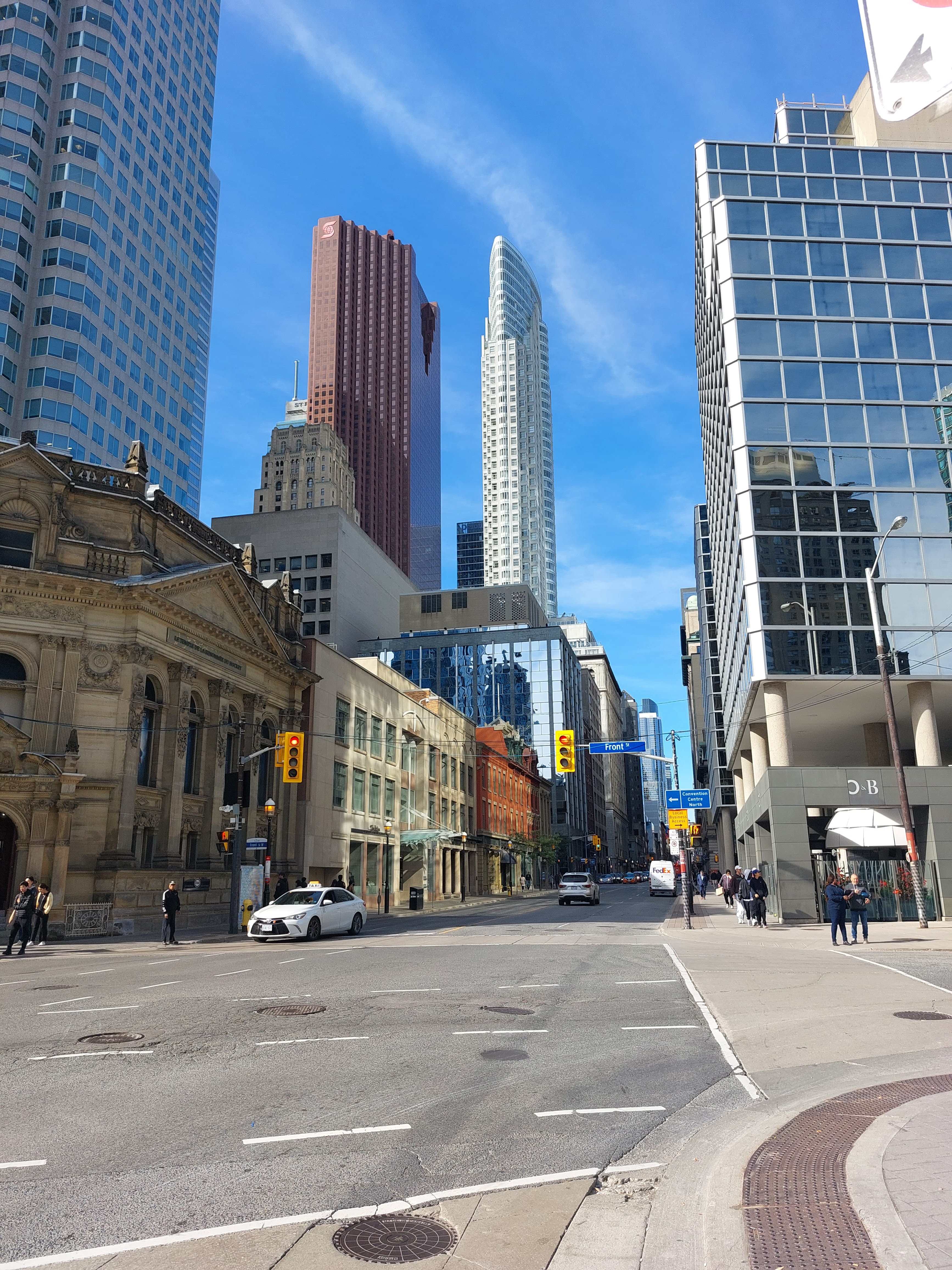
Just south of the tracks and Union Station. Royal Bank building (gold) and TD building (with 'TD' on tower on top.
Now at Front Street. Hockey Hall of Fame Building on the far left (see my
Front Street walk for more details).
Neat brick details along the top of this building.
Former Bank of British North America building, now the Irish Embassy Pub and soon to have condos above it.
Hotel Victoria. After the great fire of 1906 it was designed and built and opened in 1909 as the ‘Hotel Mossop.’ It served as an emergency hospital during the flu pandemic (1917) but closed in 1917 to be refurbished and reopened as the ‘Hotel Victoria’.
Some reasonably muted columns in this building that at various times had a "wholesale and retail boot and shoe merchant", a jewelers, and a trophy/engraving shop.
Bigger columns. Constructed in 1915 as the headquarters of the Royal Bank.
Cool detail on the
Lumsden Building (1910). When originally constructed the basement contained a swimming pool and a Turkish bath!
I've always liked the look of this building at Temperance and Yonge.
The Dineen Building (1897; hats and furs were its specialty). The link also talks about various safes that were found in the building - they were originally used for valuable fur storage but then drywalled over.
A couple of interesting buildings at Yonge and Richmond.
At left was originally
Simpsons (then The Bay and now Saks 5th Avenue).
And not to be outdone by the last building (column-wise), this is the former
Bank of Toronto building (1905) and visible at the left of the last pic.
A couple of well known theaters close together on Yonge. Here, the Elgin Winter Garden theatres…
...and here the Ed Mirvish theatre. Eaton Centre to the left, and Yonge/Dundas to the north.
Ryerson Student Learning Centre (soon to be named Toronto Metropolitan University Student Learning Centre I assume)
Just west off Yonge is the well-known Barberian's Steak House. (If I buy it I'll just have to remove the 'Barber' from the sign and leave the rest)
On the north side of Elm across from Barberian's -
St George's Hall (formerly the Arts and Letters Club).
And to the west of St George's Hall is the old YWCA (1890) - now
The Elmwood Club, a spa for women.
Looking north on Yonge coming up to College/Carlton.
College Park on the left was originally Eatons.
The old clock tower originally part of a fire hall (1872) just north of Grosvenor. Was the St. Charles Tavern for many years. Now will be part of condos.
Typical Yonge Street between College and Yonge (for now)
The building below used to be
The Gasworks - a legendary bar on Yonge at Dundonald.
And from the above link - "...its original purpose was as a steam generating plant supplying heat for the neighbourhood. In the 60s, prior to becoming the bar we all knew and loved, it had a small bowling alley upstairs (not sure what was downstairs)."
The home of the 'House of Lords' hair styling shop. Originally (1879) "designed in a second empire style".
Looking north from Yonge and Bloor
Looking north with St Clair visible in the distance. To the right is the Toronto Community Housing Corporation (TCHC) head office (see next picture).
And the
TCHC building was in the news recently.
Budd Sugarman Park, Rosedale
Neat details on a building on Yonge.
Looking north on Yonge at St Clair
Entrance to Mount Pleasant Cemetery
The Kay Gardner Beltline Park goes over Yonge at the north end of Mount Pleasant Cemetery
Davisville Yard
Toronto Transit Commission Head Office at Davisville
Impressive atrium at the Davisville Centre - NW corner of Yonge and Davisville/Chaplin (the EW street changes name at Yonge).
Fun colours and fake Tudor style building.
Looking north to Yonge and Eglinton. I almost worked for Canadian Tire in the building at left back in the day.
NW Corner of Yonge and Eglinton
It looked like the bottom part of the building would have a story. Turns out that this is Montgomery Square and the Tavern here was the staging point for the Upper Canada Rebellion of 1837.
The Art Deco building on the bottom served as a Canada Post Office from 1936.
This building (from 1932) used to house Police Station #12, currently it houses a number of agencies that promote public health
Looks like they're getting ready to save the façade. This used to be a theatre and now will be the
Capitol Residences (some interesting history in the link).
Just off Yonge on Sheldrake Blvd, this used to be the Eglinton United Church. Played badminton in their gym for many years with the Imperial Oil badminton club. Now the St. George condos.
YAHS (Yet Another Hydro Substation) - this is the Glengrove Hydro Substation.
Alexander Muir Memorial Gardens - NW entrance (looking SE)
At Lawrence and Lawrence Subway looking north.
I liked the brick detail on this Apartment building. Du Maurier Apartments (1938)
Fire Station #131. Anyone (Paul?) know the make and model of the vehicle in the foreground?
The beginning of a big hill down into Hogg's Hollow then Yonge continues up to Sheppard.
Some nice greenery around here.
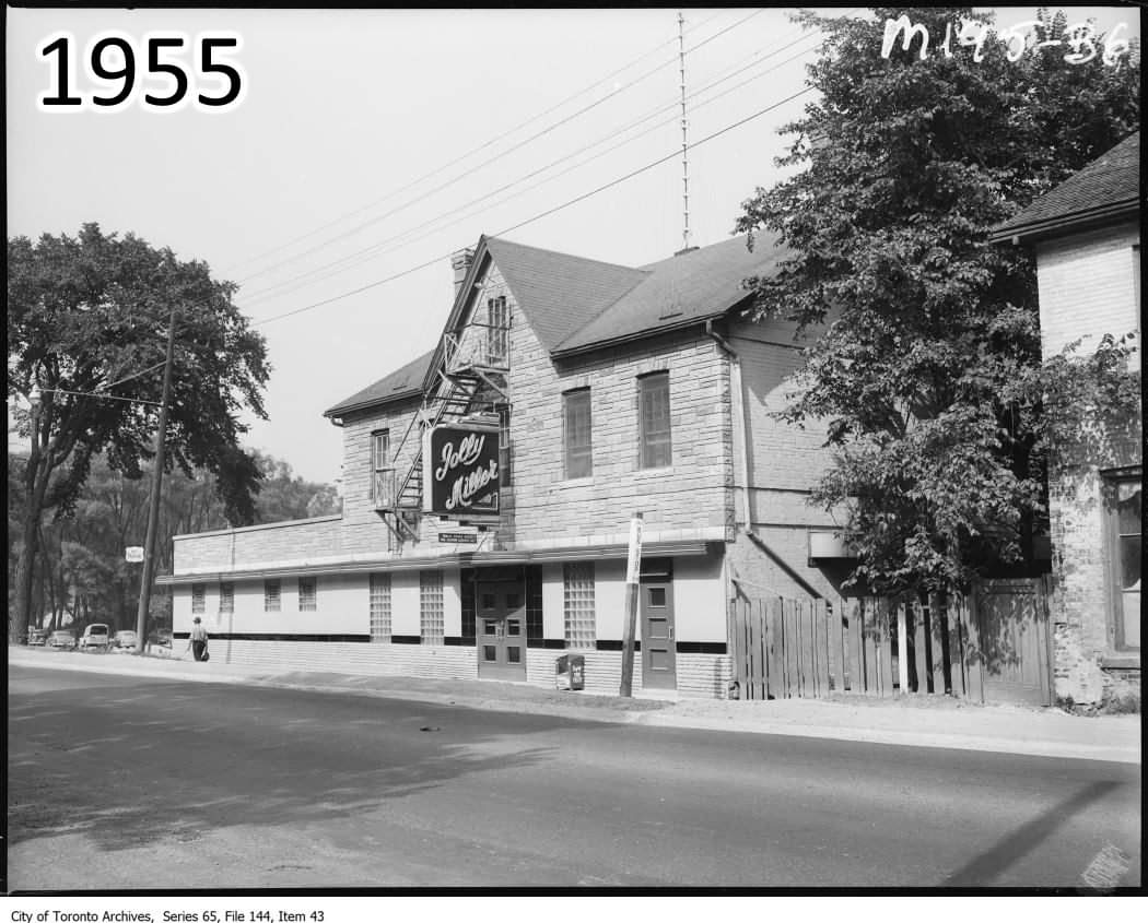
Miller Tavern at the bottom of Hogg's Hollow. Built circa 1857, and originally the York Mills Hotel.
I remember it as the Jolly Miller.
And a picture from a few years ago:
Nice little stream that comes through the Don Valley Golf Course and eventually flows into the Don River. But nearby is a plaque commemorating the
Hogg's Hollow Disaster!
Pretty techie (tekkie?) looking buildings at Yonge and York Mills/Wilson (yes, another road that changes name at Yonge).
And now a little mystery.
Saw a few of these small, low slanted buildings on the west side of Yonge around York Mills. No idea what they are, but I cleared off a few years of grime on this window…

...and could see this. ?? It's near the subway so could be a walkway to nearby buildings?
2024/06/21 Update: these are skylights for a long underground walkway from the Wilson Subway Station to the 'Yonge Corporate Centre'!
Don Valley Golf Course - accessible via a short walk from the York Mills Subway Station.
Don Valley Golf Course - first tee is behind the tree at centre. Rope-assisted walk up from the 18th green at left.
Looking north just south of Highway 401
Yonge and Sheppard coming into view. Not much more elevation gain to go now!
The unique skyscrapers just south of Sheppard.
Looking north at Sheppard. Possibly visible in the distance is the Celestica building (One of our boys did his 'after 3rd year internship' with Celestica but only went to the building once to drop off his equipment when finished 😀).
Sheppard Subway Station - heading home 'The Better Way' (the TTC).