Dundas Street winds its way east-west in Toronto, but also curves north and south (sometimes going north of Bloor Street for example!) I only followed it across the city of Toronto, but it continues west through various cities and through south-western Ontario all the way to London. (See also 'Route description' in the link above and/or look at this information on Ontario Highway 5). Further info on Dundas Street's complicated history can be found at this link and/or this one.
It became one of those 'typical' Toronto streets that combined previous streets and straightened out the 'jogs' in these streets as they crossed major streets like Yonge - since the original streets often did not meet exactly at the (now) intersections. And in the 1950's it was further widened and (in some cases) went through former alleys to become a continuous road. This was a precursor to the intent for it to become a major highway out of downtown Toronto to the east. This never came into being, due in large part to the major opposition to the Spadina Expressway. The Scarborough Expressway was part of this set of plans and was:
"...intended to link to the eastern spur of the Gardiner (which was demolished in 2000-1) at Leslie Street to the terminus of Highway 2A in West Hill. It was to cut though many east end Toronto neighbourhoods. From Leslie, it would have run along the Lakeshore to Greenwood Racetrack, then swung north to just north of Kingston Road. From there, it would have run just above Kingston Road, paralleling the CN Kingston Subdivision for a distance, then meeting up with Highway 2A near Highland Creek.
A later study of the Scarborough Expressway (1974) proposed an alternative preferred alignment running along the CN Kingston sub all the way past Carlaw, then running through the former Consumers Gas property southeast of the Broadview/Eastern Avenue intersections, with interchanges at the Gardiner, Eastern Avenue, Greenwood Avenue and Victoria Park. This would have reduced the number of homes that would have to be demolished."
In any event, this was not built, which means I had a very walkable route! This post follows Dundas from the east end (where it starts at the intersection with Kingston Road) and goes west through the downtown, then curving up, across Bloor, and then ending (my walk anyway) by the Humber River. Click on any picture to see a big version! Also part of this map.
Starting where it branches off Kingston Road (courtesy of Google Maps as I forgot to take a pic).
Toronto Police Services- 55 Division at Coxwell and Dundas
The alleyways are more rustic towards the east end of Dundas
A few blocks are pretty ugly with a line of garage doors. Turns out this is due to the way that Dundas was built in the 50's. (See the links in the first few paragraphs of this walk - specifically
this one).
"Near Jones Avenue, Dundas took the path of an old laneway, which produced a strange streetscape lined with garages and back fences."
Interesting looking building with sliding rough wooden doors to cover the doors and windows (right side of this picture near the pole). There's a better look at the Google street view
https://maps.app.goo.gl/91rer6hf1dgdCY369Turns out it is a design/build/renovation company
Laneway house just S of Dundas and a bock or so E of Carlaw
'The Carlaw' - NE corner of Carlaw and Dundas with a couple of theatres on the main floor. This is just south of our house.
Carlaw Condos - SE corner of Carlaw and Dundas
The newish rusty sculpture at Dundas Street East and Carlaw Avenue.

Mural on Dundas just W of Carlaw - part of an international art project!
https://nowtoronto.com/creative-spirit-hits-dundas
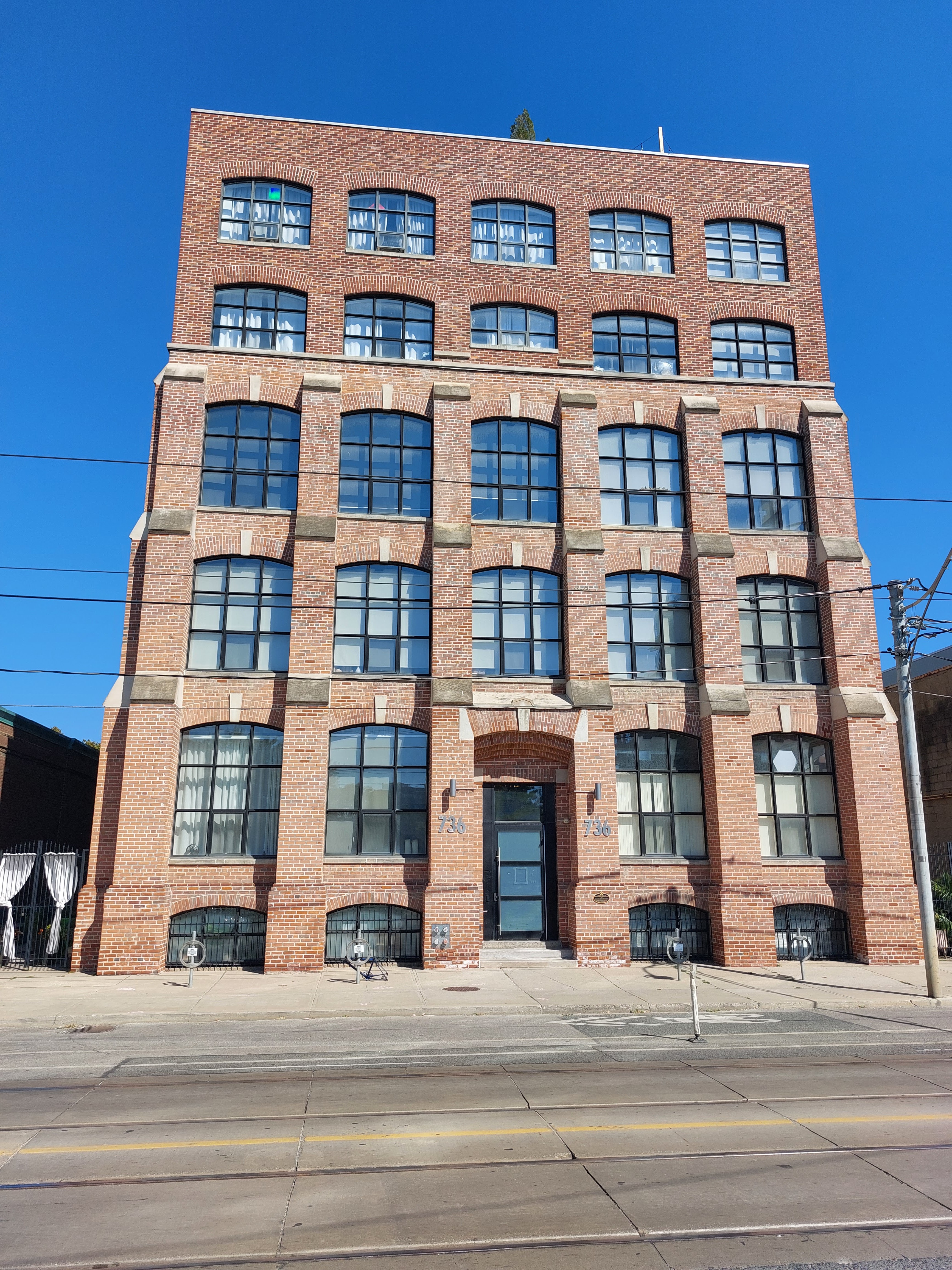
Woods Manufacturing Co. old tower (the top was originally a water tower that was bricked in).

Neat idea to have the pictures of students on the school wall! Queen Alexandria School. Done early in 2020.
Some high end car dealerships (Rolls Royce, Aston Martin, Land Rover, Jaguar) just east of the Don River - to go with the Mercedes Benz and Lexus on the other side :-)
The Mercedes dealership on the other side of the Don River was rumoured to be at least partly owned by Aretha Franklin, but this may have been from the Blues Brothers movie where she sang at this location!
https://beachmetro.com/2019/08/16/reel-beach-remembering-aretha-franklin-and-the-filming-of-blues-brothers-2000-in-toronto/
Now the Tannery Lofts. Formerly the Adam Beck Cigar Box Manufacturing building.
The new Regent Park area Aquatic Centre.
I remember going to George's Spaghetti House and listening to Moe Kaufman here at the corner of Sherbourne and Dundas East. Now True Love Cafe
And a little further east, the infamous Filmores Hotel and Gentlemen's Club (girls, girls, girls that is)
Approaching Yonge & Dundas with Yonge Dundas square on the left.
Eaton Centre and a big (!) advertising video screen
Art Gallery of Ontario (AGO)
Another neat building: "This block of second empire buildings became known as the 'Hydro Block' and was almost demolished in the 1970s in order to build an electrical substation. After major protests, the property was bought by the City and converted to affordable housing."
Though there are also condos there now.
Chinatown street scene
Some curbside vendors just east of Toronto Western Hospital
Toronto Western Hospital. Memorable for me as I had a brain tumor removed here!
Typical Toronto Police patrol - just west of Bathurst and getting into the Portuguese area
This area also has a number of references to 'Garrison Creek' (which used to run through Trinity Bellwoods Park - south of Dundas and a couple of blocks east of Ossington). For some information on this 'lost river of Toronto' see
http://www.lostrivers.ca/GarrisonCreek.htm
Bizarre mural (just east of Gladstone)
St Anne's Anglican Church (just north of Dundas at Gladstone)
SE corner of Dundas and Brock Ave.
Cool mural 1
St. Helen's Church, Rectory and Parish Hall (east of Lansdowne Avenue)

Where College Street starts (looking west on College...Dundas going left to right)
The old '
Canadian Hanson & Van Winkle Company Ltd' on Morrow Ave just north of Dundas. Now a complex of Art Galleries!
The raccoons are brewing beer now!
NW Corner of Dundas and Bloor
Dundas West Arts Building. Formerly the Ideal Aluminum Products Building and you can just see part of that name on the side of the building (top middle of this picture). The low dark grey building is now condos and some small stores.
Now getting into 'The Junction' area - named after the junction of four railway lines. Getting over (one set of) tracks - the Wallace Ave pedestrian bridge. For boxing fans, the George Chuvalo Neighbouhood Centre is a block further north on the other side of the tracks.
Formerly a 'Bank of Toronto' (later Toronto Dominion Bank) and now lofts. At Dundas Street W and Keele - NE corner
The Campbell Block building. Built in 1888, the year that 'Junction' was founded as a village. Now mixed commercial enterprises and lofts. Dundas and Keele NW corner.
For more info on The Junction see
the Wikipedia article or
this link to a local history page.
Now a residential property, this used to be The Molsons Bank building.
The William Rowntree building (1921). Has a historical designation but looks like it may be getting developed along with its neighbour.
The Cat Pub and Eatery
Another library! This one at Jane St and Dundas
Looking north from Dundas to the tracks (and St Clair Ave on the other side)
And finally, getting to the Humber River which marks the western end of Toronto.
An old willow tree
Some birds on an almost submerged rock. Humber River was fairly high after last night's rains.
Looking back up Home Smith Park Road. Houses on the right (above the high wall). Humber river to the left. And ahead is the Old Mill Subway station where I took the subway back!
And finally ending at the Old Mill Subway Station