Monday, 24 November 2025

The Queen Street Viaduct

Not as grand as the Bloor Street Viaduct (or Prince Edward Viaduct as it is more properly known) but the Queen Street Viaduct has been around in one form or another for much longer.

There have been a number of bridges over the Don River at Queen Street since the early 1800's. The current bridge dates from 1911. Looking east from the west side (see the photo below) you can see a few things:

  1. That it is a Pratt Truss bridge (for the engineers)
  2. The streetcar tracks and power lines
  3. A saying "This river I step in is not the river I stand in" across the top (that comes from the philosophy of Heraclitus)


The saying and the (now not working) clock are parts of an art installation along with words inscribed in the sidewalks at the four corners of the intersection of Queen St E and Broadview Ave and some pennants still further east on Queen St.

The four corners of Queen and Broadview contain the inscriptions:
TOO SOON FREE FROM TIME
TIME IS MONEY: MONEY IS TIME
BETTER LATE THAN NEVER
TIME=DISTANCE X VELOCITY


Also, between Broadview and the bridge there are patterns in the sidewalk that make it look like a winding river.

The earlier bridges (see the 'Queen Street Viaduct' link earlier) were much lower (closer to river level) and the Don Station building was on the west side of the river by the CPR tracks. This building has been saved and is currently at Roundhouse Park downtown. Some earlier photos follow:
1. Looking SSE from where the western end of the bridge is now

2. Looking NE from track level

The picture below was taken by me about 20 years ago while the Don Station had been located in the Todmorden Mills area further north in the Don Valley.

Now it looks like:

Some more info on the Don Station is in an earlier post I made.

Finally, some views from the bridge itself - looking north up the Don Valley Parkway:


Looking south along the river:

And looking north along the river (not the same day as above 😸 )


The old Don Jail

Having lived in various parts of the east end of Toronto for 43 years, it seemed amazing that it took this long to finally visit the Don Jail. Just walked over and walked in!

Now admittedly parts of it continued operating as a jail until 2013, but still - it's a cool building and I have walked by it many times. The original building is now the administration building for Bridgepoint Active Healthcare (with the main Hennick Bridgepoint Hospital to the west of it).

So this post is looking at what is left of the jail in the main administration building.

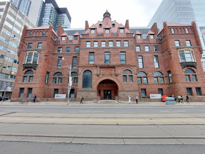
First, from the outside, an impressive entrance:


The stone sculpture over the entrance is Father Time (nobody escapes Father Time)

The main front door is quite heavy. Wood on the outside...

...and copper plated on the inside.

Stairs down to the basement.

Some kind of assembly area(?) in the basement. With a short video playing on a loop. By the way, during the entire time I was in the building I didn't see another person. Nobody at the door to say hi or sign me in. You just wander in and can follow plaques on the wall giving information and some directions (but I think I missed some, so there will need to be another visit). The administration offices were all separate so you can't go in and walk around them :-)

Here's an original cell. About three feet wide with a tiny cot pretty much filling it up.

There was also a 'segregation cell' (which looks a lot like where Harry Potter slept under the stairs for Harry Potter fans!)
Turns out that the prisoners didn't mind this because it was wider than their single cells - though it was dark with no light.

A room number with an old picture of what the jail used to look like.

Working my way up from the basement, this is the main atrium on the first floor with matching glass floor and roof designs.

Still have the arched entrances to cells - now missing their iron bars (mostly) with open office space behind.

View of the atrium from the second floor, other side.

Looking down from the middle of the second floor.

Locking sliding doors at either end of each floor.

And view from the third floor.

Finally, the fourth floor. Just to look at the heating and air conditioning details for the building. Looks like some nice ducts for escaping through - *nobody* would ever suspect that route.

Some more info on the jail and bits of its history are at the Sinai Health website at https://www.sinaihealth.ca/patients-and-visitors/the-historic-don-jail. The infamous Boyd Gang were here for a while.

And for interest, a picture of the new hospital next door:


Friday, 23 August 2024

Motordrome (Murderdrome) - Toronto

I was walking along Queen Street East about a block east of Leslie Street when I saw this mural on the side of a building. 


I wondered if it was a local store or something, but when I looked it up online it was much more interesting. It turns out that it is commemorating the racing oval that used to be here - also known as 'Murderdrome'!

Opened by the Duke of Connaught (there's also a Duke of Connaught School a block or so east) in 1914, it was a 1/4 mile wooden track built in an old brick pit and had 60° banked corners. 

It held motorbike races, bicycle races, and even cars were on the track. Amazingly, only one person died during a race:

"Ernest Roberts, caretaker of the Motordrome, Greenwood avenue, died in St. Michael’s Hospital yesterday morning. Roberts was hit on May 22 (1915) by Sayer, a motor-paced rider from Bright Beach, while cleaning glass from the track."

Turns out that: "The fans threw bottles and trash at any racer they thought was fixing a race by holding back. Workers regularly dashed to clear broken glass."

Lots of pictures (but no clear ones of the Toronto facility unfortunately) and background of the times and racers here:

https://leslievillehistory.com/devil-wagons-and-the-murderdrome-torontos-motordrome/

Sunday, 31 December 2023

Walking across Toronto - College/Carlton

College Street and Carlton Street make up another 'across the downtown' route that I took in 2022. They meet (with a bit of a north/south jog) at Yonge Street.

As always, click on any picture to see a big version! Also part of this map of my walks across Toronto.

I started at the eastern end of Carlton Street (by Riverdale Farm). This first (last?) block of Carlton starts as brick.

There are nice houses in Cabbagetown (which is what this part of the city is called).

Allan Gardens from Carlton St. A wonderful set of greenhouses dating 'way back'. This picture hides most of the greenhouses to give them a mysterious air.

Maple Leaf Gardens (now Loblaws). This is looking NW at the corner of Church Street and Carlton.

And I remember when the building on the far right of the above picture (new building; NE corner of Carlton and Church; see old photo below) was the headquarters of Warner Bros. in Canada.


A view of Maple Leaf Gardens from a year earlier (earlier than my walk that is, not earlier than the previous picture) - across the street from the main entrance.

This picture actually looks south towards a mural on a building on Yonge St - but since taken from Carlton it's included in this walk!

College Park on the SW corner of College and Yonge. Originally Eaton's until the Eaton Centre was built a few blocks south. Cool Art Deco look with brass doors, marble, and lots of architectural details.

The original 'Oddfellows Hall', later a CIBC and now various businesses (with a quite large building behind it) at the NW corner of College/Carlton and Yonge Street.

Fran's Restaurant is still here! Just west of Yonge on College.

The new (well, completed in the 80's) Toronto Police Headquarters

The original 'Victoria Hospital for Sick Children'! Now a Canadian Blood Services regional centre
https://en.wikipedia.org/wiki/Victoria_Hospital_for_Sick_Children

(Part of) the MaRS Discovery District - a private/public partnership to commercialize innovation.

And now some University of Toronto buildings. (College Street was originally named after King's College which was the start of U of T). The new 'Innovation' building is (was) under construction.

Looking N to the Ontario Parliament buildings at University Avenue

The newish (1975) Ontario Hydro building (now Intact Centre) at the SW corner of College and University

Leslie Dan Faculty of Pharmacy Building at U of T

The Stewart Building - was Ontario College of Art when I attended UofT. Now the Rotman School of Management https://en.wikipedia.org/wiki/Toronto_Athletic_Club

The Mining Engineering Building. I always liked the look of it, and that Taddle Creek would occasionally make its presence known by bubbling up from its buried location underneath!

The entrance to King's College Circle. Somewhere behind the trees on the right is the Mechanical Engineering building I attended for my Masters

Toronto Public Library entrance across from UofT

Church of Saint Stephen-in-the-Fields. Interesting Gothic look.

Looking N up Spadina to Knox College

Sneaky Dee's - restaurant/bar and live music (formerly a lot of punk rock)

Former Baptist church and now condo conversion. Not sure how many condos, but see this! https://www.blogto.com/city/2016/06/house_of_the_week_510_college_street/

The CHIN building. Some of the first multilingual radio and TV programming in Canada. 

A mural highlighting that I had just passed through one of the main Italian areas (in addition to St Clair Avenue West that is). At Ossington Avenue.

The Emmet Ray - bar on College Street. Known for hosting Euchre nights (Brenda and I have been).

Mixed commercial/condos at College and Dovercourt. Was apartments at least back until WWI (https://cgwp.uvic.ca/person.php?pid=142739)

The old 'Boys Entrance' to the YMCA at College and Dovercourt

And finally, the (western) start of College Street where it peels off from Dundas Street and starts its life.