Now I'm getting into the downtown again, and so much history! This walk starts at the north end of Parliament Street, south to Lakeshore and then north again on Sherbourne Street. We start to see a few mansions on Sherbourne (and stay tuned for more on my next walk on Jarvis Street!)
Click on any picture to see a big version! Also part of this map.
Some of you may recognize this as the tree I made a time-lapse movie of one spring. So I think it deserves a mention in this walk as I passed by it on my way to Parliament Street! According to the app on my phone this is a linden tree.

Parliament Street
At the start (north end) of Parliament Street. Looking west at the corner of Bloor (to the right) and Parliament (to the left) with a brand new condo building in the middle.


Some cheap gas on Parliament! 😀

This building looked interesting - and sure enough it has some history dating from 1888 when it was Temperance Hotel, then Lakeview Hotel (1890), and finally Winchester Hotel (to 2020).


Another theatre (building to the left - http://cinematreasures.org/theaters/24515) and some cool-looking housing to the right.

I saw this HUGE area of grass and parking lot east of Parliament just north of Shuter Street. Thinking condos in the future.






The Phoenix Concert Theatre (and people lining up to see 'NIKI - THE NICOLE TOUR').


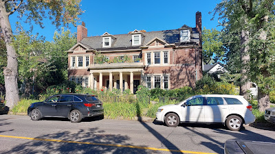


Original homes on the right losing a little sunlight due to a 'monster home' built just south of them.

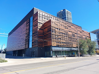
This new building is the Parliament Street Data Centre! Nice design.

Looking west, south of Front Street. This is the site of the original parliament buildings (to the left).

Very sharp corner on this building! In the distillery district. If you zoom in you will see a green skeleton on the 2nd floor beside the streetlight. 💀

Looking east at the distillery district and Gooderham and Worts Distillery buildings.

And then a short walk from Parliament to Sherbourne along Lakeshore.

Sherbourne Street
Named after a town in Dorset, UK ('Sherborne' - the extra 'u' being added at some point for some reason) by Samuel Smith Ridout, Sherbourne Street has an interesting background of killing by the rich. In 1817 John Ridout was killed in a duel by Samuel Jarvis who was acquitted of the charge of murder (since at that time participants in a duel were acquitted if the formalities of a duel were followed).John Ridout's older brother, Samuel, bought land east of the Jarvis family a year after his brother's death, on which Sherbourne Street was created. The acreage had belonged to Attorney General John White, who was killed in an 1800 duel.
Starting at the south end of Sherbourne - here's a typical saving of a couple of floors of an older building. In this case, the Imperial Bank of Canada (1908).

Here's a building - originally townhouses - built in 1842!

Now a few big homes on Sherbourne Street - each bigger than the last (if you line them up that way).
1. This is the William Dineen House (1872, updated 1895).

2. This is 260 Sherbourne Street, built 1890, now apartments. 'Richardsonian Romanesque' style.

3. The A.M. Orpen House. Abe Orpen was known for owning various racetracks. Slightly earlier picture here: https://www.acotoronto.ca/building.php?ID=2131

The plaque below says "The aviator Amelia Earhart (1897-1937?) ... lived in the St. Regis Hotel on this site from 1917 to 1919."

The Phoenix Concert Theatre (and people lining up to see 'NIKI - THE NICOLE TOUR').

Back to houses/mansions:
4. Now "Adam's House" (accommodation and support for people with mental challenges).

5. The Rev. Hoyes Lloyd House (1871) - now a Salvation Army building

6. The Rosar Morrison Funeral Home - since 1878.

This used to be a Loblaws when I lived nearby in the early '80's. Now a community centre.

Our Lady of Lourdes Parish.

The Isabella Hotel (1891). I remember it as a dive bar in the '80's but it has been transformed into a boutique hotel.
The cool older building at front was built in 1890/91 but not occupied until 1896 for some reason. It became a hotel and the seven story tower in the background was added in 1914. https://www.theglobeandmail.com/news/national/its-clean-but-the-izzys-lost-its-soul/article746209/
The cool older building at front was built in 1890/91 but not occupied until 1896 for some reason. It became a hotel and the seven story tower in the background was added in 1914. https://www.theglobeandmail.com/news/national/its-clean-but-the-izzys-lost-its-soul/article746209/

Back to houses/mansions again:
7. James Cooper house (from the south). Now part of a condo complex it was originally built in 1881 for James Cooper - a wealthy importer/manufacturer/retailer of shoes. Interesting deer/elk sculptures on the wall.
7. James Cooper house (from the south). Now part of a condo complex it was originally built in 1881 for James Cooper - a wealthy importer/manufacturer/retailer of shoes. Interesting deer/elk sculptures on the wall.

8. Yet another link to the Gooderham name! The Gooderham Mansion (1883) - or perhaps more accurately 'A Gooderham mansion'. Was the Selby Hotel for years. See also this for some history.

9. And some - originally very nice I'm sure - homes just north of Howard Street and south of Bloor will be replaced by a 50 storey condo building.

Just north of Bloor on Sherbourne and looking down on Rosedale Valley Road.

And a final set of houses on Sherbourne north of Bloor:
10. According to the Architectural Conservancy Ontario, this building was built in 1907.
First Occupant: Rennie, Thomas
First Occupant's Occupation: secretary
Valued at over $4M in 2022
First Occupant: Rennie, Thomas
First Occupant's Occupation: secretary
Valued at over $4M in 2022

11. Part of a group of buildings that were recently renovated/rebuilt, this 'semi-detached' home shares a "...below-grade garage with 24 parking spaces".

And finally the (boring side) entrance to Sherbourne Subway Station that I took home.


